
Improve your Real Estate Marketing Efforts with Aerial Photos
Traditionally, real estate photos involved pictures from the ground level, with photographers moving around the property’s interior and exterior spaces, capturing images of the rooms, architectural features, and surroundings. While these traditional methods have been useful, they often fail to provide a complete view of the property and its surrounding areas.
Aerial/drone photos offer a fresh and innovative approach to showcasing real estate. Aerial shots of properties are captured from unique angles using unmanned aerial vehicles (UAVs) or drones equipped with high-resolution cameras. Drones not only provide a bird’ s-eye view of the property but also offer a broader perspective of the surrounding neighborhood, amenities, and natural landscapes.
If you are a real estate agent, marketer, or property owner, read on to learn how incorporating aerial photos in real estate marketing materials can take your property listings to new heights.
6 Reasons Aerial Photos Are Crucial for Real Estate Marketing Success
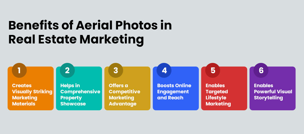
1. It Creates Visually Striking Marketing Materials
Properties need to stand out visually to capture potential buyers’ attention in a saturated market like real estate. Aerial shots offer a unique and captivating perspective that can be used to create impactful listings, brochures, online ads, and social media posts. These striking visuals immediately draw attention and pique interest. For example, an aerial photo showcasing a sprawling estate surrounded by lush landscaping and a sparkling pool can entice luxury buyers seeking an opulent lifestyle. Utilizing aerial photos in marketing materials ensures that properties make a memorable first impression and stand out from the competition.
2. It Helps in Comprehensive Property Showcase
Ground-level photos often fail to fully capture a property’s true grandeur and surrounding amenities. Aerial photos allow real estate professionals to showcase a property’s full potential in a way that engages buyers. Aerial views highlight features like expansive grounds, nearby parks, golf courses, swimming pools, and proximity to desirable locations, giving buyers a comprehensive visual understanding of what the property offers. By providing an aerial perspective, you can effectively convey the scale and unique amenities of a property, making it more appealing to potential buyers.
3. It Offers a Competitive Marketing Advantage and Faster Sales
As aerial photos in real estate marketing become a significant trend, incorporating these visuals into marketing materials can give real estate professionals a competitive edge. Establishing a unique identity enables properties to command attention, drive interest, and ultimately, secure faster sales and higher prices.
Additionally, properties that stand out with aerial photos are more likely to attract qualified buyers, resulting in expedited sales processes and shorter listing durations. Moreover, potential buyers are more inclined to explore listings with images that allow them to envision themselves living in the space. This heightened interest often translates into more inquiries, site visits, and better offers on the property.
4. It Boosts Online Engagement and Reach
Visually appealing listings and social media posts are crucial for capturing buyers’ attention and driving engagement in the digital age. Aerial pictures provide stunning visuals that encourage sharing, liking, and commenting, ultimately increasing the reach of the listing and generating more leads. Eye-catching aerial imagery can also be used to create engaging video tours and social media reels, further boosting online engagement.
5. It Enables Targeted Lifestyle Marketing
Aerial photos in real estate marketing can effectively target buyers seeking specific lifestyles by highlighting surrounding natural landscapes, recreational areas, and community features. For example, an aerial view of a property nestled in a serene mountain setting with hiking trails can appeal to outdoor enthusiasts, while an aerial picture showcasing a property’s proximity to a golf course can attract buyers seeking a golfing lifestyle.
6. It Enables Powerful Visual Storytelling
Combining ground-level imagery and aerial photos in real estate marketing enables sellers to craft a compelling narrative that takes potential buyers on a captivating journey. By immersing buyers in the property’s surroundings and lifestyle, you can evoke feelings of excitement, inspiration, and longing, compelling them to take the next step toward making the property their home.
For example, an aerial photo of a coastal property could be used to establish the breathtaking location, followed by ground-level shots showcasing the interior living spaces and amenities. The visual story could then transition back to aerial views highlighting nearby beaches, hiking trails, and recreational areas, painting a vivid picture of the coastal lifestyle the property offers.
Complementary Technologies to Combine with Real Estate Aerial Photos
1. Virtual Reality Tours
360° virtual tours provide an immersive experience where potential buyers can virtually navigate through a property as if they were physically there, viewing it from every angle. Aerial pictures can seamlessly integrate into these tours, enhancing the virtual experience by offering expansive views of the property and its surroundings. This integration allows buyers, especially those from out-of-town or international locations, to explore the property’s layout, size, and context within the surrounding area comprehensively. It allows buyers to gain a better understanding of the property’s layout, size, and context within the surrounding area, making them more likely to pursue the opportunity.
2. 3D Modeling and Rendering
Real estate professionals utilize advanced technologies to construct highly detailed and realistic visual representations of properties in 3D modeling and rendering. They create models that accurately portray both the exterior and interior features of homes, including architectural elements, room layouts, and potential design modifications. When combined with aerial photos, buyers can immerse themselves in a detailed walkthrough that provides a realistic sense of the property’s layout and potential. They can evaluate architectural details, visualize personalization options, and gain a comprehensive understanding of the property without the need for physical visits. By offering such immersive experiences, 3D modeling and rendering technology helps buyers make informed and confident decisions about their future home purchases.
3. Geographic Information Systems (GIS)
Geographic Information Systems (GIS) are utilized to analyze and visualize spatial data related to properties and their surroundings. GIS allows professionals to overlay various layers of information onto maps, such as property boundaries, zoning regulations, transportation networks, demographic trends, and environmental features.
When integrated with aerial photos, GIS enhances the visualization and analysis of real estate properties by providing a detailed, geo-referenced view. By overlaying aerial photos with GIS data layers, such as infrastructure maps and demographic information, real estate professionals can present potential buyers with a comprehensive understanding of a property’s location, its proximity to amenities, and neighborhood characteristics. GIS-based site analysis using aerial photos allows for precise assessment of property features like terrain elevation, natural hazards, and environmental sustainability. Buyers gain a comprehensive understanding of the property’s physical attributes and its suitability for specific uses or development plans.
The Art behind Enhancing Drone Images: Aerial Photo Editing
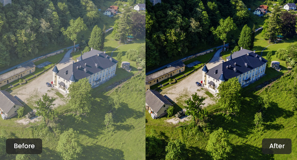
Image editing is the most crucial aspect of making your aerial photos stand out. While capturing high-quality aerial shots is essential, it is through the editing process that these images truly come to life and effectively showcase a property’s most desirable features.
Despite thorough preparation, certain uncontrollable factors can hinder the ability to capture the perfect aerial shot. These factors include lighting conditions, weather, or unexpected obstructions. This is where the importance of editing becomes paramount, as it allows you to refine and enhance the images, compensating for any limitations encountered during the actual shoot. Here are some tips to help you edit drone images and make them effective marketing materials:
1. Color Correction and Enhancement
- Adjust the vibrancy and appeal of landscaping features, pools, and outdoor amenities through color correction techniques.
- Use selective exposure and contrast adjustments to draw the viewer’s attention to specific areas of interest, such as architectural details or breathtaking views.
- Apply selective color adjustments to enhance specific elements, like making the grass greener or the pool water more clear and inviting.
- Balance the colors to create a harmonious and visually appealing overall image.
2. Perspective Correction
- Rectify distorted lines and skewed perspectives often present in drone shots with the help of perspective correction techniques.
- Ensure that buildings and landscapes appear natural and accurately represented.
- Straighten horizontal and vertical lines for a more professional and polished look.
- Correct any distortions caused by the camera lens or angle of the shot.
3. Object Removal
- Seamlessly remove distracting elements like power lines, vehicles, or temporary structures from aerial images.
- Allow the property’s best features to take center stage without any visual distractions.
- Use advanced cloning and healing techniques to seamlessly blend the removed areas with the surrounding environment.
- Eliminate any unsightly or distracting elements that may detract from the property’s appeal.
4. Atmosphere and Mood Enhancement
- Adjust the white balance and temperature to create a warm and inviting ambiance or a cooler, more contemporary feel.
- Align the image’s mood with the desired marketing message.
- Use split-toning techniques to add depth and dimension to the image.
- Enhance shadows and highlights to create a more dramatic or subtle look, depending on the desired effect.
5. Compositing and Panoramic Views
- Combine multiple aerial shots to create panoramic or 360-degree views.
- Provide a comprehensive understanding of the property’s layout and surroundings.
- Effectively showcase large estates, golf courses, or expansive natural landscapes.
- Stitch multiple images together seamlessly, ensuring consistent exposure, color, and perspective.
Opting for Professional Aerial Photo Editing Services
If you have a large volume of images and want to focus directly on core property marketing tasks, opting for professional drone image editing services can be highly beneficial. Expert service providers use industry-leading photo editing software like Photoshop, Photomatix, and Lightroom, for quick and high-quality project deliveries.
Rather than relying solely on automated filters and tools, skilled editors refine aerial real estate imagery through a human-in-the-loop approach. By blending advanced software with human expertise, they enhance the clarity, color, and composition of aerial shots. This methodology allows them to provide multi-faceted aerial image editing services, including:
- Aerial location marking: Highlight specific areas or landmarks with drop pins that serve as visual indicators to provide clear context to potential buyers.
- Layout mapping & site plan rendering: Create detailed maps and renderings combined with aerial photos. Use advanced software like CAD to showcase the property layout and surrounding area.
- Single & multiple land highlighting: Emphasize individual units or multiple properties within a single image through visual land boundaries.
- Color correction/balancing: Adjust and balance colors to ensure vibrant, natural-looking photos.
- Sky replacement: To enhance the overall aesthetic of the images, replace dull or overcast skies with clear, beautiful skies.
Outsourcing the editing task allows you to streamline your workflow and focus on what you do best: marketing properties. With expert drone photo editing services, you can ensure your aerial photos are polished, professional, and ready to attract potential buyers.
To Conclude
Aerial photos are becoming increasingly important for real estate marketing. With continuous advancements in drone technology and image editing software, capturing high-quality aerial perspectives of properties and integrating them into the marketing materials will be essential to stand out from competitors.
While virtual and augmented reality integrations grow, aerial photos will play a key role in creating immersive property experiences. Real estate professionals who invest in aerial photos will be well-positioned to effectively showcase listings and communicate a property’s full value to prospective buyers. Embracing this visual asset will be critical for successful real estate marketing strategies, faster sales cycles, and higher returns on investment.
FAQs
1. How do aerial photos impact property pricing and time on the market?
High-quality aerial shots provide a comprehensive view of the property’s features and surrounding area, allowing buyers to make informed decisions quickly. Properties marketed with aerial photos often command higher prices and spend less time on the market compared to those without such visual enhancements.
2. What are the potential challenges or limitations of using aerial photos in real estate marketing?
Potential challenges may include regulatory restrictions on drone usage, weather conditions affecting flight feasibility, and the need for skilled pilots and photographers to capture compelling aerial shots. Additionally, properties with dense foliage or complex terrain may present challenges for capturing clear aerial images. You must be aware of these factors and develop strategies to overcome them effectively beforehand.
3. How can I ensure consistency in branding and visual style across my aerial photos and marketing materials?
To ensure consistency in branding and visual style across your aerial photos marketing materials, it’s crucial to establish clear brand guidelines and standards for image editing and presentation. This involves defining color palettes, typography, and overall aesthetic preferences that reflect your brand’s identity. You can also consider collaborating with experienced aerial image editing service providers who can guarantee consistency and cohesion throughout all marketing materials.